|
|
 |
|
|
|
|
|
|
|
| |
 |
|
|
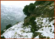
The first route begins from Sirako and leads
to Kalarites. It is a route of 4.5 km, popular
in Tzoumerka because the landscapes
you
meet really capture you. You begin from the
square of Sirako and you follow the cobbled
road until you go down to the watercourse of
River Kalaritikos. After you stop in the river to
admire the peacefulness of the landscape, you
go up an abrupt path and you meet a built scale,
which you cross. This will be the most difficult
part of the route since the path becomes smooth
|
|
|
|
as
you go towards Kalarites. In
the last part of the route you will have
the chance to admire the ravine from above and feel awe in
front of the
perfection of the nature. This route does not require
excellent fitness. In
about 1,5 hours you will be in your destination, therefore
you have no
excuse not to attempt it! |
|
|
|
|
 |
|
|
|
The
second route begins from Kataraktis and
leads to Katafridi. It is a quite long route since
its length is about 8 km. You will begin from the
square of the village in 800 meters altitude and
follow an eastern course. Soon you will meet the
stream of the village and follow the path along
the stream. You will begin to go up smooth slopes,
pass through dense forests, meet abundant
water
and later pass by alpine fields. Except
adventure,
your destination is the location Aloni. There you
will find a dirt road, which leads to the mountain
lodge. The altitude is 1.500 meters there and in
winter everything is always covered with snow.
|
|
|
Those
who want to continue the route will follow a south-eastern
course, cross
a difficult passage and go up to the top of the mountain in
2400 meters altitude.
The route is very beautiful and
you will have to be well organized and pretty fit.
The duration of the route is
6 hours and you should better avoid it during wintry
months. |
|
|
|
 |
|
|
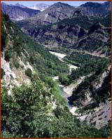
The
third route begins from Houliarades
and leads to the monastery of Tsouka.
You will begin from Houliarades in 1.000
meters altitude and follow a south-west
course. The path is downhill and it leads
to the watercourse of River Arachthos.
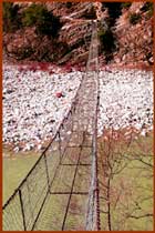
There you will go across the river
crossing
the wire bridge and continue the uphill
path, which will take you to the monastery
of Tsouka in 1000 meters altitude. The length
of the route is 5 km and it will take you about
3 hours to perform it. It is a very
beautiful
route while the view to the ravine is more
than impressive!
|
|
|
|
 |
|
|
|
|
|
|
|
|
|
|